


The Ministry of Land, Infrastructure, Transport and Tourism has set indicators and targets to understand the progress of retrofitting the seismic resistance of buildings that require seismic diagnosis, such as large-scale buildings used by an indeterminate number of people and buildings facing emergency transportation routes in the event of a disaster. The seismic resistance of buildings along evacuation routes, such as emergency transportation routes, has been delayed because the majority of them are private properties, and the plan is to set targets and targets for each prefecture from 2025 onwards. By closely monitoring local conditions, we will encourage local governments to take proactive and effective initiatives.
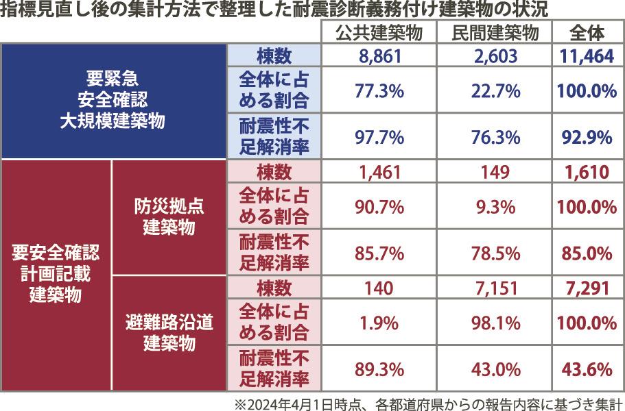
As of the end of March 2024, the retrofit rate of buildings requiring earthquake resistance diagnosis reached 92.5% for large-scale buildings requiring emergency safety confirmation, targeting hospitals and large-scale stores, based on nationally unified standards. On the other hand, "buildings with safety confirmation plans", managed by counties or cities after designating earthquake-resistant buildings and roads, are "disaster prevention bases", mainly targeting public facilities such as government buildings and evacuation areas. 72.8% are "buildings" and only 36.2% are "buildings along evacuation routes" facing emergency transportation routes.
The new index will focus on addressing seismic inadequacies, and the plan is to move to a ratio calculation method that can assess not only seismic retrofits but also demolitions and reconstructions. It is difficult to assess indicators based on local government designations because the number of target buildings, which serves as a parameter when calculating the ratio, increases over time, so in the future we will continue to monitor the number of buildings that have overcome seismic inadequacies. The aim is to use this as an indicator to appropriately assess proactive efforts by local governments, including the designation of evacuation routes.
The status of earthquake-proofing efforts varies by region. As of April, 22 prefectures and 71 municipalities have designated evacuation routes, while many cities did not designate them in the first place. At an expert meeting on the 18th to discuss the new indicators and targets, the Ministry of Land, Infrastructure, Transport and Tourism cited examples such as Tokyo, which announced the earthquake-proof status of each designated road by color coding on a map, and encouraged other local governments to implement such efforts. He also expressed his intention to expand horizontally. Architectural and academic experts also expressed the view that "visualizing" the current status of initiatives using indicators, setting targets, and maps for each prefecture would raise awareness among each local government and be effective.
The government plans to set a new target to largely eliminate earthquake resistance deficiencies in large buildings requiring urgent safety certification by 2030.
Invite partners to watch the activities of Pacific Group Co., Ltd.
FanPage: https://www.facebook.com/Pacific-Group
YouTube: https://www.youtube.com/@PacificGroupCoLt


