


Osaka Prefecture Urban Development Department: Detailed Design for Senrioka–Neyagawa Line Road and Bridge Expected in FY2026
17 November 2025 – Construction & Planning
The Urban Development Department of Osaka Prefecture plans to begin the detailed design of roads and bridges for the urban planning road, Senrioka–Neyagawa Line (Takayanagi 2, Neyagawa City to Shimo-Kanda Town, total length 1,387 meters), as early as fiscal year 2026. Although construction was initially expected to start in the same fiscal year upon project approval, schedule adjustments may be required depending on the progress of land acquisition. Currently, the department is sequentially conducting boundary inspections, creating survey maps, and investigating properties.
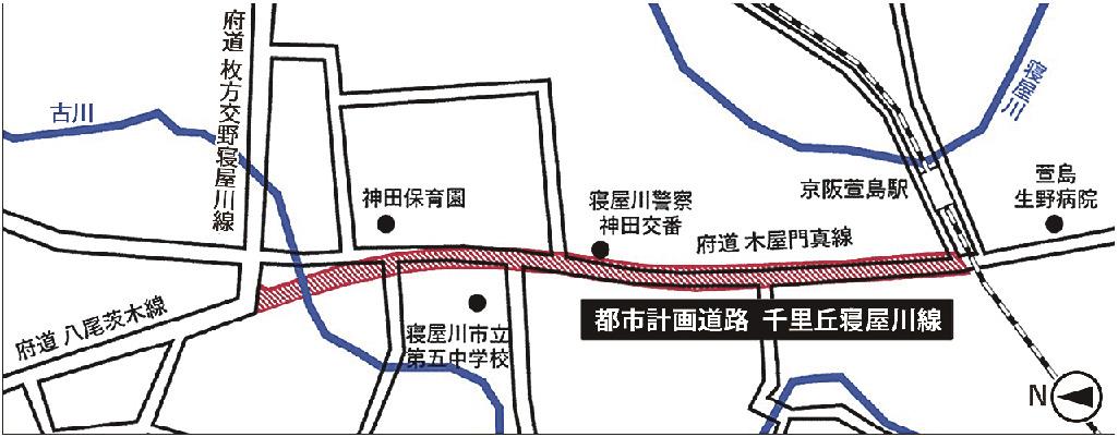
Furukawa River
Matsukata-Katano-Neyagawa Prefectural Road
Kanda Nursery School
Neyagawa Police Station
Kanda Traffic Police Station
Keihan Nukumi Station
Koya-Kadoma Prefectural Road
Nishijima Ikuno Hospital
Yao-Ibaraki Prefectural Road
Neyagawa City Fifth Junior High School
Senrioka-Neyagawa Urban Planning Road
Terminology Notes:
-
府道 (Fudō): Prefectural Road. Here, "府" (fu) refers to Osaka Prefecture.
-
警察 (Keisatsu): Police.
-
交警 (Kōkei): Traffic Police.
-
京阪 (Keihan): Name of a railway company (Keihan Electric Railway).
-
駅 (Eki): Station.
-
都市計画道路 (Toshi Keikaku Dōro): Urban Planning Road.
The planned section starts from the Osaka Prefectural Road Yao–Ibaraki Line near Takayanagi, Neyagawa City, proceeding approximately 400 meters south to merge with the Osaka Prefectural Road Koya–Kadoma Line, reaching the border area between Neyagawa City and Kadoma City (Shimo-Kanda Town). The road will be 32 meters wide with four lanes, sidewalks, bicycle paths, tree planting zones, and shared utility ducts for electric lines. Near the starting point, the Furukawa Waterway flows, requiring the construction of a bridge approximately 15 meters in length. The bridge type and foundation structure will be finalized during detailed design based on preliminary design evaluations.
This road is expected to contribute to the formation of a wide-area arterial road network connecting National Route 1 and the Second Keihan Expressway, helping alleviate chronic congestion in the Kitakawachi region, ensuring traffic safety, and improving disaster resilience. The total project cost is approximately 9.76 billion yen, including 430 million yen for surveys, 6.58 billion yen for land acquisition, and 2.75 billion yen for construction.
The project was formalized in FY2023. Preliminary road design studies (“Urban Planning Road Senrioka–Neyagawa Line Road Preliminary Design Commission,” awarded to Central Consultant) were conducted during FY2023–2024. In July 2025, preliminary bridge design was commissioned to Fukken Research & Design, with a delivery date of 25 February 2026. Land acquisition is planned for FY2025–2030, with staged negotiations with landowners based on survey results. According to approved plans, the project is scheduled for completion by the end of FY2031.


